Saturday, October 24, 2015

Population Statistics of Jamaica

Life in Jamaica 

facts by: http://countrymeters.info/en/Jamaica


The current population of Jamaica, as of October 22, 2015, is 2,783,701. 

Births this year: 41, 960
Deaths this year: 14, 292
Net migration this year: (-11, 670)
Population growth this year: 15, 997

As of 2012, the total births per woman was 2.28, more than Bahamas and Cuba. 

Current male population: 1, 370, 102 (49.2%)
Current female population: 1, 413, 599 (50.8%)


                                                      Total adult literacy rate (%) 2008-2012*
                                                                                is 87%. 
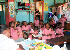
Children in a Jamaican classroom
http://www.snipview.com/q/Education%20in%20Jamaica


Immunizations of HepB, Polio, Tetanus, ect. as of 2012 were at high rates of 80-99%.
Routine EPI vaccines financed by government (%) 2012 was at 100% in 2012.
http://www.unicef.org/infobycountry/jamaica_statistics.html


Here are some statistics on AIDs and HIV in Jamaica as of 2014.

Number of people living with HIV: 29,000
Women of age 15 living with HIV: 11,000
Deaths due to AIDS: 1,300 

Thursday, October 22, 2015

3 Thematic Maps of Jamaica

Three Thematic Maps of Jamaica 


 A thematic map is a type of map specifically designed to show a particular theme connected with a specific geographic area. These maps can portray any physical, social, political, cultural, economic, or agricultural aspects of any city, state, country, region, or continent. 

-They provide specific information about particular locations.
-They provide general information about spatial patterns.
-They can be used to compare patterns on two or more maps.
  
   Situated in the Caribbean Sea, Jamaica is an island nation of the Greater Antilles, 145 mi in length, up to 50 mi in width and 4,243 sq mi in area. Jamaica is a Commonwealth realm with the Monarchy of Jamaica holding ultimate executive power. 


Population Pyramid of Jamaica- 2014 

2014
http://www.theodora.com/wfbcurrent/2015/jm_popgraph_2014.bmp
A population pyramid is a graphical illustration that shows the distribution of various age groups in a population (typically that of a country or region of the world), which forms the shape of a pyramid when the population is growing.

                      
    Political Map of Jamaica- 2014 

Updated May, 2014
http://www.qwizlas.tk/map-of-jamaica-3/
Political maps are maps that have to do with government. They show where the boundaries and locations of countries, states, cities, towns and counties are. These boundaries and locations are generally determined by people rather than nature.

Dot Distribution Map of Jamaica-2011


2011 Dot Distribution Map
http://statinja.gov.jm/MapPage/images/2011JamaicaPopulationDotDistribution.jpg
A dot distribution map is a map type that uses a dot symbol to show the presence of a feature or phenomenon. Dot maps rely on a visual scatter to show spatial pattern.